The Apps Our Instructors Actually Use at Sea
Just fifteen years ago, a lot of skippers locked their phones in a cabin locker on day one of a trip and did not touch them again until they were back on the dock. Now our phones and tablets are with us constantly, chart table, cockpit, back pocket, so it makes sense to put some of that screen time to good use.
None of what follows is part of the RYA syllabus. Think of it as the bonus material our own instructors share once the theory is covered: the apps they genuinely reach for at sea, in their own words, not a generic top ten list assembled from app store rankings.
Chart plotting and passage planning
Navionics, now owned by Garmin, is the one Alan has used the longest. It works as a chart plotter on a phone or tablet, with tidal heights and streams built in, so it can complement other navigation methods rather than replace them. Its standout feature is probably just its polish and reliability, it has been around a long time and it the team have clearly put effort into stability and usability. Alan uses it for passage and pilotage planning even when not aboard the boat: “It gives me everything I need to complement my other nav methods… I like the look and feel of the interface, and it has most of the features found on a full plotter.”
However, it also pushes on ‘community edits’. Anyone can contribute a sonar log, or add charted objects, so the data is not always trustworthy. It is worth turning the feature off in settings if we would rather stick to the surveyed base charts. Garmin’s ownership has also tightened over the years, and some long-time users feel the app has drifted towards a more profit-focused feel than it had in its earlier days.
Savvy Navvy does a similar job with a different feel. Charlie uses it mainly for passage planning, quick distance checks, and overlaying tide data, and at sea it works as a handy backup to the boat’s own systems. It builds an automatic course to steer that factors in tide, weather, and chart data, and routes around known hazards along the way. “They are always adding new useful features, like being able to add pilotage notes,” is how Charlie describes it.
Being newer to the market, it does not carry the same years of polish as Navionics yet, and it shows in the odd rough edge. What it lacks in maturity it makes up for in pace, the team ship new features constantly, and Charlie sees that as part of what is pushing the whole category to innovate rather than stand still.
Weather
Two very different approaches here, and both earn their place on our instructors’ phones.
PredictWind hosts up to eight forecast models and lets us compare them side by side. Different models can disagree with each other, so seeing them together helps us judge how much to trust a forecast before making a call. One feature Charly rates especially highly is being able to check how accurate each model has actually been for our own local area against real recorded conditions, rather than trusting a model’s reputation blind. Charly calls it “one of my favourite weather tools… really user friendly, even whilst hosting a massive range of information.”
That depth of detail comes at a price, PredictWind is one of the more expensive apps on this list, and the full routing and model comparison features sit behind a subscription.
Sail Grib takes the opposite approach: one job, done simply, with a download of around 12kb that stays on the device once it’s there. It shows wind direction and strength for any area in the world. As Edd puts it, “there is a lot to be said for a plain and functional app with a single purpose, rather than a bloated battery and data intensive piece of software,” a fair point when we’re relying on a weak signal offshore.
It earns that efficiency by staying basic, both in look and in price. A polished interface is not the draw here, but for what it does, it is hard to beat.
Tides
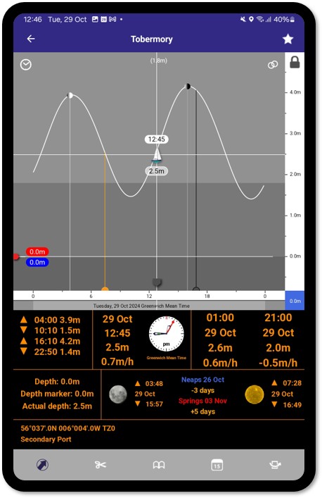
For a clear tidal curve, high and low water times and heights, springs and neaps, and even sunrise and sunset for any harbour worldwide, Alan reaches for the Imray Tides Planner. It covers over 8,000 locations and works offline, since the whole database sits on the device rather than relying on a connection. He has used it for years without much changing: “It hasn’t really changed since I first got it all those years ago, which says a lot… It’s simple and easy to use.”
That stability cuts both ways. The interface feels dated next to newer apps, and digging out predictions further ahead than the current month can mean picking through a slightly confusing subscription structure. The good news is Imray are testing a new interface that looks considerably friendlier, and their support channel has been genuinely helpful whenever we have needed it.
Anchor watch
Anchor Pro sets a swinging room, then alerts if the boat drifts outside it. Dragging anchor is often only noticed once it has already become a problem, so an early alert buys us time to deal with it calmly rather than in a rush. It tracks GPS accuracy and battery level alongside the alarm itself, and can flag either dropping below a threshold we have set, so we are not relying on a single silent assumption that everything is still working. Charlie particularly likes being able to see GNSS accuracy and when it last updated, so we can judge how much to trust the alarm rather than take it on faith. It sits alongside a boat’s own systems rather than instead of them, “great to have additional control than you might have on many chartplotters,” as Charlie puts it.
Keeping GPS running continuously overnight to watch the anchor does drain the battery faster than normal, so it is worth starting the night on a proper charge, or running it alongside a battery bank, rather than assuming a phone will comfortably last until morning.
Local pilotage
This one is regional rather than universal. Antares Charts provides highly detailed private survey charts of specific anchorages and passages, built up over years of independent surveying in areas that had barely been resurveyed since the Victorian era. Charly, sailing the Hebrides, rates the detail well above the standard admiralty charts for those areas. If we sail somewhere Antares covers, it is 100% worth having.
The coverage is genuinely local though, limited to the Hebrides, so this is one to check before assuming it will help outside that specific cruising ground.
For the more curious among us
GNSS View, or a similar GPS data app, is more of a teaching tool than an everyday sailing app, but it is worth knowing about. Alan mainly uses it for teaching purposes: it shows exactly where the GNSS satellites are in real time, along with an HDOP figure, a number that gives a feel for how accurate a GNSS fix is likely to be at that moment. Handy for understanding how the electronics we already rely on actually work under the surface.
It is not one we would expect to open every day, more one to pull out occasionally when curiosity gets the better of us, or when explaining GNSS accuracy to a student in a way that clicks better on screen than on paper.
A few things worth remembering
None of this is a reason to stop paying attention.
Using a phone at the helm has caused more than a few accidents, so if reaching for an app means taking our eyes and hands off the boat at the wrong moment, it can wait.
A phone or tablet at sea is also limited by battery and by internet connectivity, which tends to drop out at exactly the wrong moment offshore. Keep devices charged when they are not in use, and know in advance which apps still work with no signal.
These apps sit alongside official charts, forecasts, and the knowledge from our RYA training, not instead of them. A new app is worth learning and testing before we actually need it at sea, not during a moment when we are relying on it for the first time.
Frequently asked questions
Do we need all of these apps before taking our course?
No. None of this is part of the RYA syllabus, and plenty of skippers sail well with just one or two of these, or none at all. They are additions to build a toolkit over time, not a checklist to complete before setting off.
Will these apps replace what we learn on a theory course?
No, and that is rather the point. Every instructor who shared a pick here also holds proper qualifications and years of experience working with paper charts, tide tables, and dead reckoning first. The apps sit alongside that grounding rather than substitute for it.
Which one should we try first?
Start with whichever solves a problem we already have. If tide times are the fiddly bit, Imray Tides Planner is a gentle place to start. If passage planning ashore is the goal, Navionics or Savvy Navvy make more sense.